One Month to Go! --- A trip full of Unknowns
One month from today, I will be starting my hike on the Pacific Crest Trail! It feels very strange how close it is, especially as I have been planning this trip for around two years.
Unfortunately, it is now obvious that this year will not be a "normal" thru-hiking year, as it has been an extremely high snow year in California's Sierra Mountains. Postholer is a site that I have been frequently checking throughout the winter, watching the snow depth graph slowly rise higher and higher. As shown below, this year's line sits just above 2017's, the highest snowpack recorded in recent history.
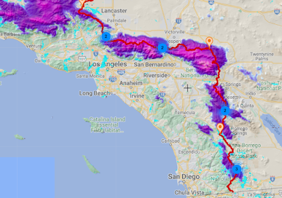
The last series of snowstorms even impacted the southern-most parts of the PCT, and early season hikers are reporting a consistent 12-24 inches of snowpack starting less than 40 miles into the trail. The forecasted rising temps in the next couple weeks will hopefully melt most of this desert snow.
At this point, I am still planning on starting on my scheduled start date of April 7th, but I will continue to monitor snow conditions in the desert. While hiking the entire trail in one continuous footpath would be the goal in a "normal" snow year, I recognize that this is not a reasonable expectation this year. Entering the San Jacinto mountains and Sierras in a high snow year presents many challenges such as dangerous stream crossings (where rapid melt swells creeks above their safe fording level), constant postholing, and not to mention that hiking in deep snow is much slower and much more exhausting.
I am starting to let go of my hopes for a continuous thru-hike. I imagine that I will either skip the San Jacinto range (the first major obstacle on the trail) in its entirety, or find a series of alternate trails that will bypass the most treacherous parts. Currently there is over 200 miles of the PCT closed in the San Bernardino mountains, which are closed until at least March 16th. If I manage to successfully navigate the snow in SoCal and make it to Kennedy Meadows, the start of the Sierras, I fully expect that the snowpack will still be extremely high. Skipping the Sierras and rejoining the trail at some point in Northern California might be a possibility, but there will likely be a lot of snow there too.
While having to get off the trail would be disappointing to say the least, I am not going to risk putting myself in danger. If at any point on the trail I encounter dangerous conditions that I am not properly prepared for, I am fully fine with the idea of simply turning around and walking back to town. I have toyed with the idea of getting off trail at Kennedy Meadows (or before then), heading to Holden Village for a month or two, then getting back on trail in mid July or August to experience the prime hiking season in Oregon and Washington.
By the time I get to Kennedy Meadows, I will have hiked about 700 miles, which I expect to take about 40-50 days.
Ultimately, I will take the trail one step at a time, and most likely everything that I'm saying will be irrelevant in a month or two. When planning a trip of this scale, I've found that planning everything out ahead of time is usually entirely pointless.
Let's talk about gear!
After a very successful last trip to REI last week, I can now say that I have dialed down over 90% of my gear, with only minor things that I need to take care of.
- ULA Circuit Backpack (teal thing on the right)
- Gossamer Gear the One Tent (this tent weighs only 17.7 ounces and requires trekking poles to be set up)
- Thermarest Neo-Air XLite Sleeping pad (system coupled with a NEMO switchback pad cut to a shorter length for additional warmth)
- Paria outdoor products 15 degree sleeping quilt (a budget quilt that I have used for several years)
- Sawyer squeeze water filter (many people have asked me where do I get water on the trail, and this is it! I fill up my Cnoc 2 liter bladder at any stream/water source I find on the trail, attach the filter and squeeze the water into one of my Smartwater bottles)
- Kahtoola microspikes (A piece of gear that is crucial during a high snow year such as this one. I plan on carrying these from the start of the trail, and they provide traction)
- Lightheart Gear Rain Jacket
Please leave questions in the comments! If I get enough questions I will make another post before I leave addressing them!


This is super exciting! Glad that you have some flexibility baked into your planning.
ReplyDeleteGreat post. I like your attitude about the weather and the snow.
ReplyDeleteHow much will your pack weigh? How much food will you need to carry? Probably depends how far between towns I guess.
Such great details!
ReplyDeleteI’m envious!
I’d love to be a mouse on your shoulder and enjoy your hike with you!
Been thinking about you during the wicked snow storms in CA, glad to hear that you have some alternatives that you're thinking about. I guess that timing really is everything! Sending prayers.
ReplyDeleteCheryl
So what percentage of your starting weight will be food?
ReplyDelete